Provide Car Accident Forecasting Maps With Machine Learning Predicting Car Accidents By Learning To Drive
Researchers Have Been Able To Provide High-Resolution Road Accident Prediction Maps With The Help Of Machine Learning.
Communication routes in cities and roads are becoming more complicated and crowded. Although technologies such as digital positioning, car vision, and mobile software help a lot in navigation, drivers still rely more on traffic signs and lights.
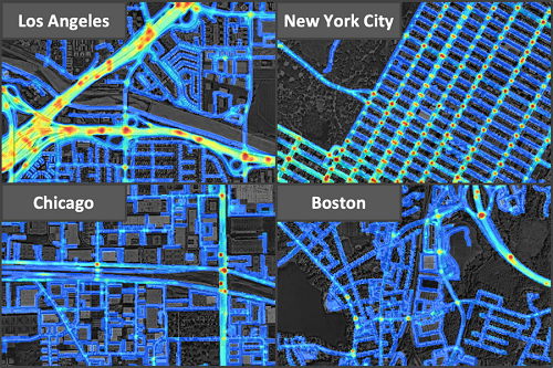
Researchers at MIT University’s Computer Science and Artificial Intelligence Laboratory have developed a machine learning model that provides accurate crash prediction maps with the Qatar Center for Artificial Intelligence.
This intelligent system is powered by data such as accident records, road maps, satellite imagery, and GPS tracking and can predict high-risk areas and possible accidents.
Usually, traffic hazard maps have a low resolution and an accuracy of several hundred meters. New maps show that, for example, the risk of accidents on highways is higher than on roads near residential areas, or the risk of accidents at the entrances and exits of streets is higher than on other routes.
This approach helps car insurance companies adjust insurance contracts based on their customers’ routes. In addition, urban planners can use these forecasts to design safe routes.

Researchers have been able to provide high-resolution road accident prediction maps with the help of machine learning.
Our model can predict crash maps in unknown areas. “This is a step towards achieving comprehensive artificial intelligence,” said Amin Sadeghi, a Qatar Computer Research Institute senior fellow, and a research team member. Mohammad Alizadeh, a professor of electrical engineering and computer science at MMIT University, also contributed to the project.

